The predominant explanations for the deep roots of contemporary African (under)development centre on the influence of Europeans during the colonial period (Acemoglu et al 2005), and on the slave trade in the centuries before colonisation when close to 20 million slaves were exported from Africa (Nunn 2008).1 Yet another milestone took place amidst these two major events. In new research (Michalopoulos and Papaioannou 2011) we study the consequences of the "Scramble for Africa", which started with the Berlin Conference of 1884–85 and was completed by the turn of the 20th century. In this brief period, the prospective colonisers partitioned Africa into spheres of influence, protectorates, colonies, and free-trade areas. The borders were designed in European capitals at a time when Europeans had barely settled in Africa with little knowledge of the geography and ethnic composition of the areas whose borders were designing. Despite their arbitrariness these boundaries endured after African independence. As a result, in most African countries a significant fraction (around 40-45%) of the population belongs to groups that have been partitioned by a national border. Yet while case studies suggest that the main impact of Europeans’ influence in Africa was not colonisation per se, but the improper border design, there is little – if any – work that formally examines the impact of ethnic partitioning. Our work is a first step to fill this gap.
Identifying partitioned ethnicities
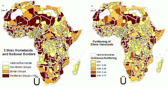
Quantifying the effects of the Scramble for Africa requires identifying the partitioned groups. To do so we use anthropological data from the pioneering work of George Peter Murdock (1959), who has mapped the spatial distribution of 834 ethnicities at the time of colonisation in the mid/late 19th century. In Figure 1 we project on top of Murdock’s map the current boundaries of African countries and classify as partitioned groups those ethnicities with at least 10% of their total surface area belonging to more than one country. There are 231 ethnic groups with at least 10% of their historical homeland falling into more than one country. When we use a more restrictive threshold of 20% there are 164 ethnicities partitioned across the national border.
Our procedure identifies most major partitioned ethnic groups. For example, the Maasai have been split between Kenya (62%) and Tanzania (38%), the Anyi between Ghana (58%) and the Ivory Coast (42%), and the Chewa between Mozambique (50%), Malawi (34%), and Zimbabwe (16%). We also calculate the probability that a randomly chosen pixel of the homeland of an ethnic group falls into different countries. The ethnic groups with the highest score in this index are the Malinke, which are split into six different countries; the Ndembu, which are split between Angola, Zaire, and Zambia; and the Nukwe, which are split between Angola, Namibia, Zambia, and Botswana.
Figure 1. Ethnic homelands and national borders in Africa
Were borders arbitrarily drawn?
In spite of the conspiracy theories, “the study of European archives supports the accidental rather than a conspiratorial theory of the marking of African boundaries” (Asiwaju 1985). Not only did Europeans have limited knowledge of local geographic conditions, since, with the exception of some coastal areas, the continent was largely unexplored, but at the time Europeans were not drawing borders of prospective states or – in many cases – even colonies. As the British Prime Minister at the time Lord Salisbury summarised: "we have been engaged in drawing lines upon maps where no white man's feet have ever trod; we have been giving away mountains and rivers and lakes to each other, only hindered by the small impediment that we never knew exactly where the mountains and rivers and lakes were."
In the first part of our empirical analysis we formally establish border artificiality. With the sole exceptions of the size of the historical homeland and area under water, we are unable to detect any other significant differences between partitioned and non-partitioned ethnicities with respect to a variety of geographical and ecological characteristics as well as regarding early development and early contact with Europeans. We further show that there are no systematic differences between split and non-partitioned ethnic groups, across several pre-colonial ethnic-specific institutional, cultural, and economic features.
The violent repercussions of the random border design
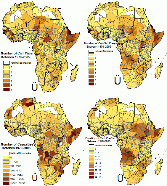
We then employ the Scramble for Africa as a quasi-natural experiment and assess the impact of partitioning on civil conflict, as this has been theorised to be the main channel of influence. In contrast to most previous works examining the long-run effects of historical factors on development and the voluminous literature on the correlates of civil conflict that have relied on cross-country comparisons (see Blattman and Miguel 2010), we use regional data performing the analysis at the historical ethnic homeland level. Figure 2 below portray the spatial distribution of civil conflict across ethnic homelands.
Figure 2. The spatial distribution of civil conflict across ethnic homelands
Our regional focus allows us to control at a fine level for geography, the disease environment, natural resources, and other factors that may independently spur conflict and under-development. We also account for all country-level factors that affect civil war, such as institutional quality, ethnic fragmentation, foreign aid, national policies and for broad cross-ethnicity differences in pre-colonial institutional and economic traits.
Using detailed data on the location, duration, and total casualties of all civil wars in Africa in the post-independence period (1970–2005), we show that civil conflict is concentrated in the historical homeland of partitioned ethnicities. We obtain similar results even when we restrict our analysis across ethnic homelands close to the national border. Our most conservative estimates suggest that civil conflict intensity, as reflected in casualties and duration, is approximately 25% higher in areas where partitioned ethnicities reside (as compared to the homelands of ethnicities that have not been separated).
The groups with the highest incidence of civil war are the Afar and the Esa, which during the period from 1970 to 2005 have experienced five civil wars. Both groups have been greatly impacted by artificial borders, the Afar being partitioned between Ethiopia, Eritrea and Djibouti, and the Esa being split between Ethiopia and Somalia.
Spillovers
Besides quantifying the direct effect of ethnic partitioning on conflict, we document significant spillovers to areas adjacent to split ethnicities. Spillovers emerge for numerous reasons. First, the battleground between a partitioned ethnic group and the central government (or another ethnicity) might extend beyond the historical homeland of the partitioned ethnicity. For example, the battles between the Somali and Ethiopian tribes have not taken place solely across the border. Second, in many cases the conflict in the homeland of the partitioned ethnicity leads to displacement and refugee flows to nearby areas, which in turn may spur conflict. For example, the discriminatory policies of Mobutu Sese Seko against the Alur led to their displacement from Zaire, affecting adjacent regions both in Zaire and in Uganda.
Our analysis uncovers substantial spillovers. The deleterious consequences of partitioning are not limited to the homeland of split ethnic groups. Tribal areas adjacent to the ethnic homeland of partitioned groups also experience more civil wars, which tend to last longer and be more devastating. Our estimates imply that an ethnic group residing adjacent to a partitioned ethnic homeland is on average 5% more likely to experience civil conflict, ceteris paribus.
Conclusion
We have examined the consequences of a neglected aspect of colonisation, the Scramble for Africa, which resulted in the partitioning of several African ethnicities across different countries. Partitioned ethnicities have suffered systematically more from civil conflict compared to groups that have not been directly affected by the improper border design. We further show that civil conflict is not only concentrated in the historical homeland of partitioned ethnic groups, but groups adjacent to split ethnicities are also more likely to experience longer and more devastating (in terms of casualties) conflicts.
The uncovered differences in the probability and intensity of civil war between partitioned and non-partitioned groups become more dramatic when viewed in light of the fact that these two groups of ethnicities were socially, culturally and economically similar in the eve of colonisation and at the time of African independence. Our work thus suggests that the Scramble for Africa, by partitioning ethnicities in different countries, shaped the trajectory of these societies by spurring civil conflict and unrest.
References
Acemoglu, Daron, Simon Johnson, and James A Robinson (2005), “Institutions as a Fundamental Cause of Long-Run Growth” in Philippe Aghion and Steven Durlauf (eds), The Handbook of Economic Growth, Amsterdam: Elsevier.
Alesina, Alberto, William Easterly, and Janina Matuszeski (2011), “Artificial States”, Journal of the European Economic Association 9(2): 246-277.
Asiwaju, A. I. (1985): “The Conceptual Framework,” in Partitioned Africans, pp. 1-18. New York: St. Martin Press.
Blattman, Chris, and Edward Miguel (2010), “Civil War,” Journal of Economic Literature, 48(1), 3-57.
Dowden, Richard (2008), Africa: Altered States, Ordinary Miracles, London: Portobello Books Ltd.
Englebert, Pierre,.Stacey Tarango, and Matthew Carter (2002), “Dismemberment and Suffocation: A Contribution to the Debate on African Boundaries”, Comparative Political Studies, 35(10): 1093-1118.
Gennaioli, Nicola and Ilia Rainer (2007), “The Modern Impact of Precolonial Centralization in Africa”, Journal of Economic Growth, 12(3): 185-234.
Herbst, Jeffery (2001), State and Power in Africa, Princeton: Princeton University Press.
Michalopoulos, Stelios and Elias Papaioannou (2010), “Divide and Rule or the Rule of the Divided? Evidence from Africa”, CEPR Discussion Paper 8088.
Michalopoulos, Stelios and Elias Papaioannou (2011), “The Long Run Effects of the Scramble for Africa”, CEPR Discussion Paper 8676.
Murdock, George Peter (1959), Africa: Its Peoples and Their Culture History. New York: McGraw-Hill Book Company.
Nunn, Nathan (2008), “The Long Term Effects of Africa’s Slave Trades”, Quarterly Journal of Economics, 123(1): 139-176.
1 Some recent works also emphasise the effect of deeply rooted pre-colonial ethnic institutions in shaping contemporary economic development in Africa. Gennaioli and Rainer (2007) present cross-country evidence of a robust positive association between pre-colonial political centralisation and the contemporaneous quality of public-goods provision and institutional quality. Michalopoulos and Papaioannou (2010) show that even when one looks within African countries or focuses across adjacent ethnic homelands there is a strong positive correlation between the degree of ethnic political centralisation at the time of colonisation and regional development, as reflected in satellite images on light density at night. See our previous VOX piece.